London Postcodes Explained: A Practical Guide to Areas, Districts and What They Mean
A practical guide to London postcode areas, districts, borough links, and how to use them for homes, services, transport and local discovery.
London Postcodes Explained: A Practical Guide to Areas, Districts and What They Mean
London postcodes can feel confusing at first, especially if you are new to the city, looking for a place to rent, comparing boroughs, or trying to understand why two streets that look close on a map can have very different prices and reputations. A London postcode is more than a delivery code. It often gives clues about location, transport, property demand, local identity and even how people describe an area.
This guide explains how London postcodes work, what the letters and numbers mean, how postcode areas relate to boroughs, and how you can use them when searching for homes, services, markets, transport links or local information across London.
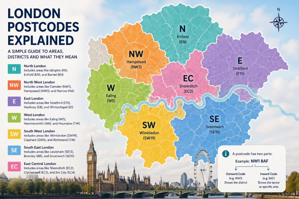
What is a London postcode?
A postcode is a short code used to identify a small geographic area for mail delivery. In London, postcodes are also widely used in property searches, local service directories, delivery apps, transport planning and online maps.
A full UK postcode usually has two parts:
Example: NW1 8AF
The first part is called the outward code. In this example, that is NW1. It points to a broader postal district.
The second part is called the inward code. In this example, that is 8AF. It narrows the location down to a smaller group of addresses, sometimes a single building, part of a street, or a cluster of properties.
So when someone says they live in NW1, they are usually referring to a wider district. When they give the full postcode NW1 8AF, they are identifying a much more specific location.
Why London postcodes matter
London is a large city made up of many overlapping identities: boroughs, neighbourhoods, transport zones, historic villages, high streets, estates, business districts and postal areas. Postcodes help organise that complexity.
People use postcodes to:
- search for flats and rooms
- compare areas before moving
- check whether a property is near a station
- find schools, GPs, councils and local services
- estimate delivery availability
- identify local businesses
- understand where a street or market is located
- compare property prices and rental demand
For example, a search for “flats to rent in NW3” usually means the person is interested in Hampstead, Belsize Park or nearby North West London areas. A search for “markets near E1” may point to Whitechapel, Spitalfields, Brick Lane or parts of Tower Hamlets.
Postcodes are not perfect, but they are very useful for local discovery.
The main London postcode areas
London postcodes are grouped by compass-style areas. These letters usually describe the broad direction from central London.
| Postcode area | General meaning |
|---|---|
| E | East London |
| EC | East Central London |
| N | North London |
| NW | North West London |
| SE | South East London |
| SW | South West London |
| W | West London |
| WC | West Central London |
There are also many outer London postcodes that do not follow the simple London compass pattern, such as BR, CR, DA, EN, HA, IG, KT, RM, SM, TW, UB and WD. These often cover outer London boroughs and neighbouring areas outside Greater London.
This is one reason London postcodes can be confusing: not every London address has a postcode beginning with E, N, NW, SE, SW, W, WC or EC.
For example:
- Harrow often uses HA postcodes.
- Croydon often uses CR postcodes.
- Bromley often uses BR postcodes.
- Kingston upon Thames often uses KT postcodes.
- Hillingdon may include UB postcodes.
- Havering may include RM postcodes.
So a postcode can be in Greater London even if it does not look like a “classic” London postcode.
Postcode areas vs boroughs
A borough is a local government area used for council services, planning and council tax. A postcode area is postal geography created for sorting and delivery. They overlap, but they are not the same.
This means one borough can contain several postcode areas, and one postcode area can cross more than one borough.
For example, Camden includes postcodes such as NW1, NW3, NW5, WC1, WC2 and others. But those postcode districts may also connect with nearby boroughs or areas.
Likewise, SW1 covers parts of central London associated with Westminster, Victoria, St James's and nearby areas. But the identity of SW1 is postal, not the same as a borough boundary.
When searching for a home or local service, it is useful to check both:
- the postcode district, such as NW1, E1 or SW19
- the borough, such as Camden, Tower Hamlets or Merton
Together, they give a better picture of the location.
Postcode districts and local identity
In London, some postcode districts have strong identities. People often refer to them as shorthand for an area.
- NW1 - Camden Town, Regent's Park, Euston and nearby areas
- NW3 - Hampstead, Belsize Park and parts of North West London
- E1 - Whitechapel, Aldgate, Spitalfields and parts of East London
- E2 - Bethnal Green and surrounding areas
- E8 - Hackney and Dalston areas
- N1 - Islington, Angel and parts of North London
- W1 - Soho, Mayfair, Fitzrovia and central West End areas
- SW1 - Westminster, Victoria, Pimlico and St James's areas
- SW19 - Wimbledon and nearby areas
- SE1 - London Bridge, South Bank, Bermondsey and Waterloo areas
This is why postcode pages are useful for local discovery. They connect users to stations, markets, businesses, and practical services in a way borough-only pages often cannot.
How to read a London postcode
Let's take the example: SW19 5AE
The outward code is SW19.
- SW means South West London
- 19 identifies a more specific postal district, commonly associated with Wimbledon and nearby areas
The inward code is 5AE. This narrows the location to a much smaller delivery area.
Another example: E1 6AN
- E means East London
- E1 is a district associated with areas such as Whitechapel, Aldgate and Spitalfields
- 6AN identifies a smaller address group
When browsing local information, the first part of the postcode is usually enough to understand the general area. For exact directions, deliveries, official forms or property checks, the full postcode matters.
Inner London and outer London postcodes
London postcodes can also give a rough sense of whether an area is inner or outer London, although this is not always exact.
Inner London postcodes often include: EC1, EC2, EC3, EC4, WC1, WC2, W1, SW1, SE1, E1, N1, NW1.
Outer London postcodes often include: BR, CR, HA, KT, RM, SM, TW, UB.
However, London does not work only in neat rings. Some outer areas are very well connected by rail or Underground, while some inner areas can still feel quiet or residential. Always combine postcode information with transport, local amenities and borough data.
Postcodes and transport
Postcodes are very useful when checking transport connections. A postcode can help you find the closest Underground, Overground, Elizabeth line, National Rail, DLR or bus connections.
- NW1 may connect users to Camden Town, Euston, Mornington Crescent, King's Cross St Pancras or nearby stations depending on the exact address.
- E14 may connect to Canary Wharf, Poplar, Heron Quays, South Quay or Crossharbour.
- SW19 may connect to Wimbledon, South Wimbledon, Wimbledon Park or nearby rail and tram services.
- SE1 may connect to London Bridge, Waterloo, Southwark, Borough or Elephant & Castle.
This is important because two properties in the same postcode district can have very different transport convenience. One may be a five-minute walk from a major station; another may require a bus connection.
When comparing areas, always check:
- nearest station
- walking time
- transport zone
- night transport options
- bus routes
- commute time to work or university
- weekend service changes
A postcode is a starting point, not the full transport story.
Postcodes and property search
Postcodes are heavily used in the London property market. Many people search by postcode district because it gives more precision than a borough but more flexibility than a single street.
- NW3 may attract people looking for Hampstead and Belsize Park
- E8 may attract people looking for Hackney and Dalston
- SE22 may attract people looking for East Dulwich
- SW11 may attract people looking for Battersea and Clapham Junction
- W2 may attract people looking for Paddington, Bayswater or Hyde Park areas
But be careful: postcode reputation can influence price. Some postcode districts are strongly associated with expensive or fashionable areas, while neighbouring districts may be more affordable.
When searching for rent or property, do not rely only on the postcode name. Look at:
- exact street
- building type
- transport distance
- council tax band
- local shops
- safety perception
- noise levels
- parking
- nearby parks
- property condition
- lease terms
Postcodes can help narrow the search, but they do not replace viewing the property or checking the local area.
Postcodes and council tax
Council tax is handled by borough councils, not by postcode areas. This is another reason to avoid confusing postcodes with boroughs.
Two homes with similar postcodes may fall under different councils if they are near a boundary.
Before renting or buying, check:
- which borough council covers the address
- the council tax band
- whether bills are included in the rent
- whether you qualify for a discount or exemption
- whether the property is registered correctly
Postcodes and local services
A postcode can help users find nearby services, including:
- GP surgeries
- dentists
- pharmacies
- schools
- nurseries
- supermarkets
- markets
- tradespeople
- emergency services
- council offices
- libraries
- community centres
A useful postcode page might include borough, nearby neighbourhoods, stations, markets, verified businesses, listings, public services, emergency contacts and related guides.
Postcodes and markets
Markets are a strong part of London's local identity. Many people search for markets using area names, but postcodes can make those searches more specific.
- markets near NW1
- farmers markets in SW19
- food markets near SE1
- vintage markets in E2
- street markets near W1
For CheckLondon, this is a strong opportunity: postcode pages can link to market pages, borough pages and station pages.
Are London postcodes always accurate for neighbourhoods?
Not always. A postcode is accurate for delivery, but it may not match how people describe neighbourhoods.
A good rule is: Use the postcode for precision, the borough for administration, the station for transport, and the neighbourhood name for local identity.
Common London postcode examples
| Postcode | Commonly associated areas |
|---|---|
| W1 | Soho, Mayfair, Fitzrovia, Marylebone |
| WC1 | Bloomsbury, Russell Square, Holborn |
| EC1 | Clerkenwell, Farringdon, Barbican |
| SE1 | London Bridge, South Bank, Waterloo, Bermondsey |
| E1 | Whitechapel, Aldgate, Spitalfields |
| E2 | Bethnal Green, Shoreditch edges |
| E8 | Hackney, Dalston |
| N1 | Islington, Angel, Canonbury |
| NW1 | Camden Town, Euston, Regent's Park |
| NW3 | Hampstead, Belsize Park |
| SW1 | Westminster, Victoria, Pimlico |
| SW3 | Chelsea |
| SW7 | South Kensington |
| SW11 | Battersea, Clapham Junction |
| SW19 | Wimbledon |
| W2 | Paddington, Bayswater |
| W8 | Kensington |
These associations are useful, but they should be treated as general guidance, not exact legal boundaries.
How to use postcodes when moving to London
If you are moving to London, postcodes can help you compare areas quickly.
Start with your main priorities:
- commute time
- rent budget
- transport zone
- safety and comfort
- schools or childcare
- nightlife or quiet streets
- access to parks
- access to markets and shops
- distance to friends or family
- local services
Then compare postcode districts rather than only borough names.
How businesses use London postcodes
Local businesses also use postcodes to describe service areas. A plumber, cleaner, electrician, removal company, estate agent or courier may serve specific postcode districts.
Examples:
- serving NW1, NW3 and NW5
- covering E1, E2 and E8
- available across SW London
- specialising in Wimbledon and SW19
Examples of useful search pages include verified cleaners in NW1, emergency plumbers in Ealing postcodes, removals in SW19, and property services near SE1.
Tips for understanding a London address
When checking any London address, look at five things together:
- Full postcode - gives the exact postal location.
- Postcode district - gives the broader area, such as NW1 or SW19.
- Borough - tells you the council and local authority.
- Nearest station - tells you how connected the location is.
- Neighbourhood name - tells you how people usually describe the area.
A good local listing should show all five. This makes the information clearer and helps users avoid confusion.
Frequently asked questions
Are London postcodes the same as boroughs?
No. Postcodes are postal areas. Boroughs are local government areas. They often overlap, but they are not the same.
Can one postcode district cover more than one borough?
Yes. Some postcode districts cross borough boundaries or sit close to them. Always check the exact address if council services matter.
Why do some London postcodes start with BR, CR, HA or RM?
Outer London areas often use postcode areas based on historic postal towns or surrounding districts, not the central London compass system.
Is a postcode enough to judge an area?
No. A postcode gives useful location information, but you should also check transport, street, property condition, council, local amenities and safety.
What is the difference between NW1 and NW1 8AF?
NW1 is a postcode district. NW1 8AF is a full postcode that identifies a much smaller group of addresses.
Do postcodes affect rent prices?
Indirectly, yes. Some postcode districts are strongly associated with desirable or expensive areas. But exact street, building quality and transport links also matter.
How can I find nearby markets or services by postcode?
Use the postcode to locate the area, then check nearby borough pages, station pages, market pages and local business listings.
Final thoughts
London postcodes are one of the easiest ways to understand the city at a local level. They help connect addresses to areas, transport, boroughs, services, markets and property searches, but they should not be used alone.
The best way to understand a London location is to combine the postcode with the borough, nearby stations, local neighbourhoods and practical services. For people moving to London, renting a flat, finding local businesses or exploring markets, postcodes are a powerful starting point.
On CheckLondon, postcode pages are designed to help you move from a simple code to useful local information: where the postcode is, which borough it belongs to, what stations are nearby, what markets and services exist in the area, and which related guides can help you make better decisions.